

Jouni Laaksonen 2.4.2018
Last week I dabbled a bit with Google Maps. I like Google’s map services, including satellite images and Google Earth, if I’m studying some area in a faraway land where no better maps are available. At least not easily, and not for free on-line. Google Maps were good help in understanding where the hiking would take place in Myanmar or Georgia, for example.
Sometimes I’ve also used OpenStreetMap. Open source, made by everyone to everyone, sounds great! And works great, too, sometimes. When we were planning a holiday in Tenerife and later in Madeira, I explored the hiking possibilities first with OpenStreetMap. There are some contour lines here, good! (And now that I’m checking it anew, I have to say it has more to it than I remembered – when I’m checking a popular hiking destination. Not quite so in less popular wildernesses.)
However, after that initial exploring I bought a proper paper outdoor map and guidebook. With all the contour lines, hiking trails, services and so on.
When there are good topographic maps available, I choose them every time. In Finland there are excellent topographic maps on-line, free for anyone to use. They are fantastic in planning a hike, and you can print copies for day hikes. Same is true of Norway (Norgeskart, Ut.no) and Sweden, and probably in many countries I don’t know of.
For longer expeditions it is better to buy paper outdoor maps (Karttakeskus, Calazo), which are very good quality. I have dozens of Karttakeskus maps on my shelf and I use them regularly. I can really recommend them. I have less experience of the newcomer, Calazo, but their maps look good, too.
How is it in your country? Are the maps good? Are they available not only as paper maps, but also on-line? For free? It would be great to get links to various good topographic map sites around the world in the comment field.
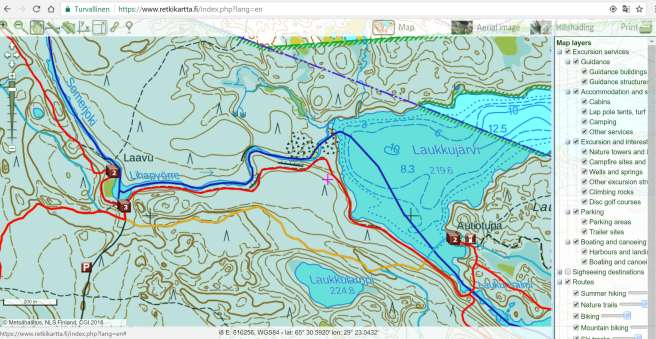
Let’s see small part of Finland’s newest national park, Hossa, in Google Maps, MapSite and Excursionmap, in this order.


I have not used much Google Maps, and I’m sure there is a lot more to them than I know. I only just learned Google Maps shows you the shortest driving route from A to B, and shows kilometers. And embedding is a great feature. And so on.
And here’s the same place in OpenStreetMap. Some contour lines, but not nearly enough. The lean-to is shown, and on other map layer the wilderness hut is shown, but for some reason the lean-to is not shown on that layer. Same remark here as in Google Maps: I haven’t used OpenStreetMap much, so I’m no expert in using it.

In MapSite and Excursionmap, you can see precise set of contour lines (=uphill, downhill, how steep etc), forest vs. bog (and what kind of bog), paths, springs, streams, lean-to (Laavu), wilderness hut (Autiotupa), bridge and so on.

This is one example of what you see in good topographic maps. There’s a bridge of a marked hiking trail over river Somerjoki when it continues downwards from lake Laukkujärvi (lower left corner in the maps above). No mention of a bridge or path in Google maps. Path and continuous black line over the river (=bridge) in MapSite map. Marked hiking trail over the river in Excursionmap (and if you click the red line off, you see the bridge under it). Thumbs up for OpenStreetMap, it seems to show this bridge.
Excursionmap.fi is often the best of the internet maps for hiker in Finland, for it shows different kinds of trails: deep blue lines are paddling routes, red lines are hiking trails, yellowish lines are mountain biking trails, and light blue lines are ski tracks. Brown squares are spots with hiking infrastructure. P is naturally parking area, and a square with a number means there are as many things in that spot as the number indicates. When you click the 2 in lower left corner you get information about campfire site and wilderness hut. Light green background color means this is conservation area.
Topo maps vs. aerial images
Now, you might point out that there are satellite images in Google Maps. Yes, and also in MapSite and Excursionmap (though under name Aerial images).
I remember an acquaintance of mine argued a decade ago that as aerial images are getting better and better, soon nobody needs topographic maps. I strongly disagree. Aerial images are a very good addition to topographic maps, but I can’t see them replacing a proper map ever. A topographic map is work of an expert. An expert mapmaker has studied aerial images and also walked throughout the area he/she is making the map about. As a result you get a map that shows everything that is important, like paths, springs, rapids, rocky patches, bogs that are passable, bogs that are impassable, reindeer fences, gates in reindeer fences, duckboards and so on. You cannot see these on an aerial image, or at least not many of these.
Sometimes aerial images are of great help. I’ve found for example good wading point over a river with use of aerial images. Usually topographic maps show every rapids (=potential wading place), but sometimes you find more rapids from aerial images.
I mentioned contour lines earlier. I haven’t hiked a lot abroad, but some. For example in Madeira and Austrian Alps I have understood very well why you usually need to stick to marked trails there. When the contour lines are something like 50 or 100 meters intervals it really means the area is so mountainous you often cannot choose your own routes.
In Finland contour lines are at 5 (five) meter intervals. You can walk to every fell top in Finland, there’s no need for climbing skills or equipment. Of course there are some gorges you cannot walk crosswise and some fellsides you need to go round, but generally you can very well choose your own route outside any paths.
Maps vs. GPS
What about GPS? Satellite navigation is a great invention masterpiece of engineering. At best it lets many such people go to nature who would be afraid to go without. The gadget always tells you where you are, and which way you should go to reach your goal. You may be interested in searching geocaches: GPS is your tool. Or a smartphone with GPS.
But still paper topographic map and compass is the best pair of tools in many occassions. They do not need electricity, and they work just as fine in -30C as in +20C. They do not suffer malfunctioning. And it is very useful to see all of your daily march at one glance. A map with an apt scale lets you do just that, and at the same time it precise enough to tell your whereabouts at every situation.

On a week-long hike in Urho Kekkonen National Park. It’s late in the afternoon now and today we will only descend to river Muorravaarakanjoki. Tomorrow we will ascend over those fells on the horizon…
Of course you need more navigation skills to use map and compass than with a GPS, but that’s part of the fun!
I want to navigate always with map and compass. I’m a bit afraid if I started to use GPS I would get lazy about navigation and perhaps lose some of my skills there. And I very much like the challenge and the good feeling when you make good decisions about choosing the route and finding your goal as you planned.
Well, I do have a wristwatch with GPS. It is handy when I find something interesting like a rare flower, ancient reindeer hunting pit or some such. I take a picture of the coordinates, and that way the exact location is recorded in the same folder on my computer as the pictures. (No, my camera does not have GPS. I like a camera with as little battery use outside of actual photographing as possible. That way the battery lasts longer in freezing temperatures.)
Also I guess the GPS-watch gives some feeling of security. If I would get completely lost, I could see my position. I’ve used the watch this way once or twice, and both times I felt lazy afterwards. I could have done it the good old way: stopped, sat down, eaten something and started to ponder with map, my compass bearing and clock where I must be, approximately. Which way I need to continue to bump into something I cannot miss.
But the bottom line is: There are many ways to navigate, and many good sources of maps. There isn’t one ‘proper’ way to hike. Understand your skills and limits and choose your destination accordingly. Use whatever method you are comfortable with and go to the wilds! 🙂
* * *
Next week I’ll tell a tale of a memorable solo ski touring expedition through large and rarely hiked wildernesses in Lapland. Skiing conditions both on ski tracks and off tracks are at their best in April in Lapland.

My partner in crime and I have a very similar philosophy when it comes to maps and going outdoors. Google offers a lot of help when planning a hike and getting information on the area, but on the trail nothing is better than old school paper map. Although, some areas even in Europe are poorly mapped (Old Yugoslavian areas etc.), and then you are more than happy to have a GPS. 🙂 Have you used Wikiloc ever?
LikeLike
No, I haven’t used Wikiloc. Good to know of it, have to check it out more properly some time! I was maybe a bit provocative in my phrasing, or at least concentrated very much on the Nordic countries… Your point about poorly mapped areas is good, and a GPS unit is very handy there.
I remember in late 1990’s when we were hiking in Russia east of Archangelsk. We had some kind of maps, but the area was laaaarge old-growth spruce forest with very few distinctive landmarks. My friend’s GPS (which was quite new invention those days) was a good help.
LikeLike