

Jouni Laaksonen 25.2.2019
I’m fond of navigating the good old way, that is, with a map and compass. However, there’s no denying that modern technology helps a lot with navigating, if you wish so.
Are you familiar with GPX tracks? A year ago I wasn’t, but now I know something about them. Simply put, a GPX track is a set of coordinates that defines a specific route. If you download a GPX track of a hiking trail, your satellite navigator, or GPS wristwatch or smartphone shows you how the trail goes, and whether you are on the trail or if you have walked astray. Very handy!
Using GPX tracks in smartphone
My guidebook Hiking in Finland – Day trips and Backpacking Expeditions was published in June 2019. In the book I present the Finnish way of hiking, our nature, seasons, the wilderness skills and gear needed and so on, and also I describe the very best hiking destinations in Finland. There are good topographic maps and ton of photos in the book, and also waypoint lists, but it’s not possible to fit all the trails and hiking suggestions on maps with book page dimensions. I have created a GPX track for over 130 trails or hiking suggestions, and I will publish those GPS tracks here on my blog as soon as the book is out. You’ll find a new subpage “GPX tracks” then on the header bar. (Later addition: Published. You need a password to access page GPS tracks, the password can be found in book page 128.)
How to use the GPX tracks? You can download the GPX file to your GPS navigator, smartphone map application or wristwatch GPS and use it while hiking. If you use a GPS navigator or a wristwatch with GPS, you probably know how your own device works, and I’m not an expert on every device. No, I’ll concentrate here on smartphones and to be more precise, on Android. If your system is different, I believe you’ll still get the idea of how handy GPX tracks can be, and you can find out how to make them work in your device.
There are many map applications for smartphones into which you can import GPX tracks. See, for example, Locus Maps, GPX Viewer or Oruxmaps, in your application store. More on Map apps on my earlier blog post.
I’ll post here two examples of the GPX tracks I’ve created for my book. Varkaankuru Velhopolku is a short well marked nature trail in Pallas-Yllästunturi NP, very suitable for day hiking. Kiilopää–Luirojärvi circuit on the other hand is a six to seven days backpacking tour in Urho Kekkonen NP, outside marked trails.
If you read this blog entry with your smartphone and touch Varkaankuru Velhopolku link above, your smartphone downloads the GPX file of that trail. If you have previously installed one of the applications I mention above, or some other application that understands GPX files, opening the downloaded GPX file with your smartphone should show you on a topographic map how this 4 km trail goes.
And if you travel to Finland and decide to explore Pallas-Yllästunturi NP, you can follow this nature trail with your smartphone and this GPX file. (Well, this is so well marked a trail you don’t need a smartphone to follow it, but it might be interesting to see how each trail exactly goes when you are planning your journey.)
Or, if you download Kiilopää–Luirojärvi circuit, you’ll see how this unmarked but popular loop into the heart of Urho Kekkonen NP goes along forests paths, over treeless fells, beside lake shores and across the rivers. (When I’ll open the page “GPX tracks” you’ll get also all the wilderness huts and other interesting points along the route, but here’s just the track for testing.)


Here’s three screenshots from my smartphone. 1. I click the link Kiilopää–Luirojärvi circuit here on this blog post, and a second later at the bottom of the page the phone tells me that file U_KiilopaaLuirojarviCircuit.gpx was downloaded. When I click Avaa (=Open), my smartphone asks which application I want to open the file with. 2. and 3. In the two pics above the application is GPX Viewer, which is a handy and free tool. The maps are surprisingly good, but not perfect…

…and I like more Locus Map, or Oruxmaps, with the topographic map data of National Land Survey of Finland. See more on my blog post about Map apps.
Using GPX tracks on computer
Note, however, that the GPX files are also handy with your computer, to see exactly where each trail is situated. In my guidebook there will be good maps of many of the trails described, but there’s no room for a map of every one of the over hundred trails. Also there cannot possibly be room for a map of a week long route in a book.
This is where GPX tracks also come handy: When you read the book and you are interested in how exactly this Kiilopää–Luirojärvi circuit goes, you can open a topographic map on your computer, upload the GPX file provided there, and then follow the route description on just the map zoom level you wish to use.
There are many ways in which you can use GPX data on a computer. If you have a GPS receiver, you will probably have PC software such as Garmin Basecamp, too. You can import the GPX file using that.
One way to see the trails on proper topographic maps is to use www.paikkatietoikkuna.fi. You need to log in (it’s free), and then use the icon Import your own datasets. Beforehand you have to make a zipped file of your GPX file.

It may take some learning, but the result is great. Here below is how Paikkatietoikkuna shows Kiilopää–Luirojärvi circuit on two zoom levels. Naturally you can zoom in or out just as you wish.


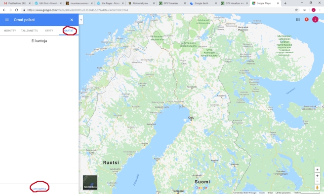
Google Maps does not provide topographic outdoor maps, but the satellite image is sometimes handy. You can upload selected GPX files there, too. Sign in to My Maps, create a new map and then import the GPX file.
My Google Maps is in Finnish, but I try to translate the terms to English. First you have to be signed in. It’s free. Then click the three lines on upper left corner and find My places. Under that you choose Maps (“Kartat” in my screenshot), and then Create a map (“Luo kartta” in my screenshot).

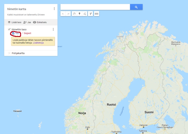
A box opens and tells you to select a GPX file from your computer. If you select the GPX track for Kiilopää–Luirojärvi circuit, you’ll get these:
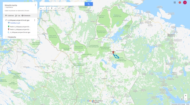
If you zoom out, as I did above, you nicely see in what part of the country the track is situated.

However, the Google Map material is not much of use in wilderness, as you see above…

…but the satellite image is more helpful.
A great free tool is www.gpsvisualizer.com. You can convert waypoint lists to GPX files, or visualize GPX tracks on maps, or much more. The JPG maps provided for Finland are not much of use, but in some other countries perhaps yes. With GPS Visualizer you can also see the track on Google Maps or Google Earth. Here’s how Kiilopää–Luirojärvi circuit looks like at Google Earth, all the loop in 2D and one part of it in 3D:


* * *
If you are not interested in using smartphones or GPX tracks for navigating, this post must have been very dull to you. Rest assured, next post will be about winter hiking with nice photos. 🙂

one can download GPX of US trails for FREE with a Chrome extension https://gomaps.ml
LikeLike
Thanks! I know nothing about US trails, but have to check that out some day.
LikeLike
My friend wrote a useful comment for iPhone users, but for some reason WordPress didn’t accept his comment. I have no idea why not. Anyway, there are many operating systems and phone models, and I don’t know much about them. I just know what works on my phone (Android, Samsung). My friend Jouni (yes, same first name as mine), had problems with iPhone, and he solved them like this:
—
Thanks Jouni for sharing the tracks. I spent quite a while trying to get
the tracks to my iPhone from the web browser. I had to admit that it
doesn’t work as expected. All browsers (tried Safari, Chrome & AdBlock
Browser) in iPhone simply refuse to share or store the file as GPX and
only allow me to share or store a link to it.
The options that work are that you either
#1 Download the .gpx on your computer and then send an email to yourself
with the file attached. You can then open the .gpx file from the email
message, and iPhone then suggests to import it to any of the GPX apps
you have installed or allows you to Save it to Files.
or
#2 Use the DropBox application. If it’s installed, you can share the
file link from the browser with DropBox, then store the .gpx file to
your own DropBox and then Export it from there (not Share, since that
means to share the DropBoxlink with someone). Then you can select any
GPX app to open it with or Save it to Files.
I also found a couple of good alternatives to use as viewers.
#A Open GPX Tracker is a free open source viewer, which can use
OpenTopoMaps and
#B Jahtikartta (shown as Outdoor GPS map in AppStore), which use Finland
topo maps Kapsi (same as Retkikartta (excursionmap.fi) it seems) and
also similar options for Sweden and Norway. It also has a convenient
distance measurement tool, for example.
#C Topo Maps Finland – this costs a bit but seems to be the best option
in practice. It can save some areas for offline use better that the
others (it seems) and functions very smoothly. The only darwback is that
it brings all tracks and locations in the GPX files as separate
“bookmarks” so it’s difficult to remove or handle them all as groups.
These all even work in my old iPhone 6 with iOS 12.
—
LikeLike